Alternatives
🇧🇬 За версия на български натиснете тук. 🇧🇬
- CyclOSM
- Bulgarian mapping and cycling-related NGOs and projects
- Strava heatmap
- Komoot
- Copy the map for personal edits
CyclOSM
CyclOSM is based on the data of an open-source project called OpenStreetMap and seems to have the best coverage of official bike lanes in Bulgaria and international routes. It is, however, not accessible thorugh Google’s various services and is therefore not equivalent to the goals of this current project, which aims to be as widely available as possible on software that most Bulgarian mobile users already have and understand. Furthermore, it doesn’t seem to support satellite imagery, Street and 3D view, which are very helpful when planning a route.
CyclOSM focuses on a more objective approach to cycling routes, as it aims to document existing dedicated infrastructure and not reflect subjective opinions of contributors.
“It aims at providing a beautiful and practical map for cyclists, no matter their cycling habits or abilities. In urban areas, it renders the main different types of cycle tracks and lanes, on each side of the road, for helping you draw your bike to work route. It also features essential POIs as well as bicycle parking spots or spots shared with motorbikes, specific infrastructure (elevators / ramps), road speeds or surfaces to avoid streets with pavings, bumpers and bike boxes, etc.
The map is available by default in the following smartphone applications:
OSMAnd, All-In-One Offline Maps or AlpineQuest Rando GPS and OpenMultiMaps”
Bulgarian mapping and cycling-related NGOs and projects
Sofenhagen
A project bringing together information, events and maps about cycling, which the users of this project will surely find useful. They have a great map with many routes in the west of Sofia, which is a good complement to the routes included in the “Velosofize personal edition” map.
Велоеволюция (velobg.org)
This project was critical for the creation of Velosofize, as the first draft of the map was largely based on their own map of official bike lanes in Sofia. They don’t, however, seem to be actively maintaining the map currently.
Interactive map
(⭐) Save in Google Maps
Zerowastesofia
A collaborative project to map water fountains and zero-waste friendly establishments in Bulgaria. They have apps for Android and iOS as well. Maps for Sofia and for all of Bulgaria are available along with additional information.
Interactive map
(⭐) Save in Google Maps
Strava heatmap
Strava is a great alternative, given their huge amount of data collected from users tracking or uploading their workout routes through the app. The trajectories of all the users who’ve passed through a particular location are overlaid to highlight given roads, lanes, etc. This lets everyone “vote” for given routes without the need to manually input or rate them. Routes that one wouldn’t have discovered by chance quickly become apparent. The following locations are also visible on their map:
- Bike lanes
- Public water fountains
- Bicycle parts and repair shops

The downside is that, in my opinion, there is a certain bias in favor of major boulevards, which are often neither safer, nor more convenient, nor more pleasant to ride on than the quiet neighborhood streets running in parallel, but are the obvious choice for passing riders who don’t know the area well or for very advanced/brave cyclists. Also, many of its features are paid (heatmap is free to use, albeit with ever increasing restrictions).
Komoot
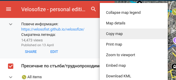
Copy the map for personal edits
Copy the map to your Google Drive to make changes to a separate copy: